ORLANDO, Fla. – Hurricane Dorian is slowly marching through the Atlantic Ocean, close to Florida's coast.
The most recent track issued by the National Hurricane Center removes Florida from the cone of uncertainty, however, Florida's eastern coast will still feel potentially dangerous impacts from Dorian.
Outer bands of the Category 4 storm continue to move in and spread out Monday night into Tuesday morning. Hurricane Dorian was downgraded to a Category 2 storm just before 11 p.m. Tuesday.
According to Dorian's current track, conditions are expected to deteriorate late Monday with the worst of the weather from the storm arriving Tuesday night and Wednesday.
Outer bands that can contain tropical storm force gusts, torrential rain and isolated tornadoes are expected to move in Monday afternoon. This could also lead to flooding throughout various parts of Central Florida. Emergency management officials also warn residents to be ready for severe weather. Read county by county impacts below.
County-by-county impacts
The worst of the storm arrives Tuesday and Wednesday, where a majority of Central Florida will feel the impacts of Hurricane Dorian.
These impacts are based on Hurricane Dorian's latest track and can change as the storm shifts in the Atlantic.
Brevard, Volusia, Flagler counties

The greatest impacts will happen along the coast, but significant impacts are possible in the I-95 corridor.
The forecast track shows the storm just north of Cape Canaveral around 8 a.m. Wednesday. This means the wind and rain will last a little longer but will gradually clear and will follow the storm from south to north with Flagler county experiencing the last of the storm by Wednesday night.
Flagler, Coastal Volusia and coastal Brevard counties could experience wind gusts between 50 and 75 mph on Tuesday and Wednesday. Inland Brevard and Volusia will experience gusts up to 50 mph.
As of Monday, Brevard County is under a storm surge warning, with rain predicted to bring up to 8 inches of rain. Isolated areas could see up to a foot of rain. With the latest advisory from the National Hurricane Center, storm surge and hurricane warnings have been extended northward along Florida's east coast to the Flagler/Volusia County line.
Seminole, Osceola, Orange and Polk counties
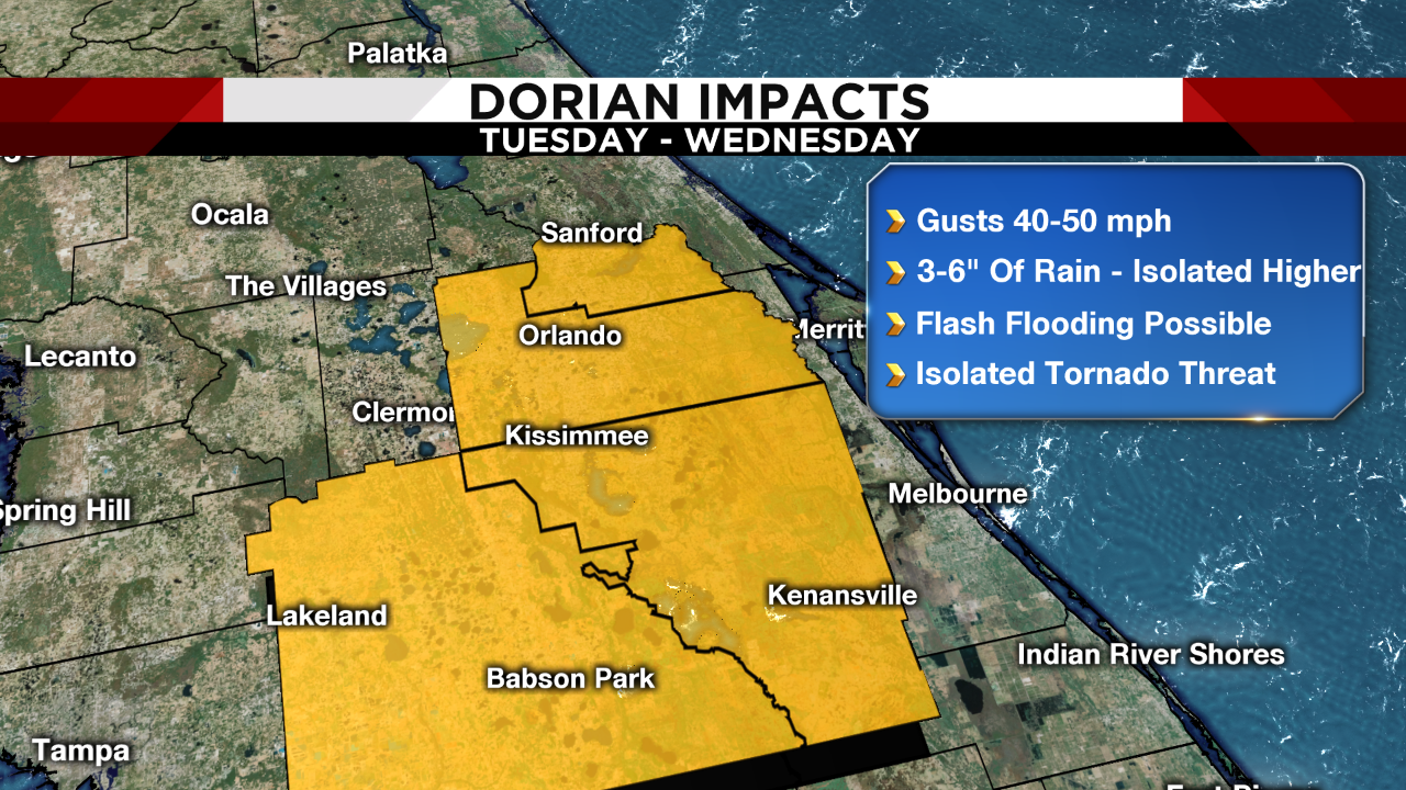
People residing inland may experience tropical storm force winds and anywhere from three to six inches of rain. Flash flooding is possible, especially for low-lying areas. As of Monday, Dorian's track shows a low tornado threat for the three counties. Osceola, Seminole and Orange counties are under a tropical storm warning.
Osceola, Orange and Seminole counties could experience wind gusts between 40 to 50 mph on Tuesday and Wednesday.
[RELATED: What's the difference between weather watches and warnings? ]
Marion, Lake, Sumter counties

These inland counties will have a low tornado threat. Isolated flash flooding is to be expected as Dorian is forecasted to bring tropical downpours. As of Monday, parts of Lake County are under a tropical storm watch. People in these counties can experience winds anywhere near 40 mph.
[RELATED: Hurricane Dorian: Watches, warnings issued in Central Florida ]
Expect to lose power, especially east of I-95, as wind gusts ramp up overnight Monday. Conditions begin to improve late Wednesday and into Thursday.
You can see when these conditions move in to your area by downloading our Hurricane Tracker App. News 6 meteorologists will send alerts as Dorian tracks closer to Florida.